


Satellite-ASIGN
Deskripsi Satellite-ASIGN
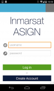
Satellite-ASIGN is an experimental version of UN-ASIGN for crowdsourcing geo-referenced photos, text and disaster needs forms via satellite communications. The intention is to share the data for free with the international humanitarian disaster management community, United Nations, Civil Protection.
Using this App, the communication cost over satellite would not need to be covered by the users of the App. General rights to the photos belong to the users, but Inmarsat is given the rights to share with users and organisations related to this cause. Specifically the observations will be offered to the UN, for integration into live satellite maps.
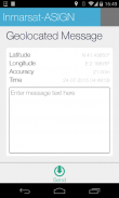
Satellite-ASIGN offers interactive mission-critical visual communications capabilities with geo- and time-tagged photos, where users first send a small preview of a photo, that can be assessed for operational relevance. If and as needed, selected content can later be interactively fetched from the original photos contained within the App.
Satelit-asign adalah versi percobaan dari UN-asign untuk crowdsourcing Foto geo-referenced, bentuk teks dan kebutuhan bencana melalui komunikasi satelit. Tujuannya adalah untuk berbagi data secara gratis dengan masyarakat internasional kemanusiaan penanggulangan bencana, PBB, Perlindungan Sipil.
Menggunakan App ini, biaya komunikasi melalui satelit tidak akan perlu ditutupi oleh pengguna dari App. hak umum untuk foto-foto milik pengguna, tapi Inmarsat diberikan hak untuk berbagi dengan pengguna dan organisasi yang terkait dengan masalah ini. Khususnya pengamatan akan ditawarkan kepada PBB, untuk integrasi ke dalam hidup peta satelit.
Satelit-asign menawarkan mission-critical kemampuan komunikasi visual interaktif dengan geografis dan waktu-tagged foto, di mana pengguna pertama mengirim preview kecil dari foto, yang dapat dinilai untuk relevansi operasional. Jika dan sesuai kebutuhan, konten yang dipilih nantinya bisa interaktif diambil dari foto asli yang terkandung dalam App.
Satellite-ASIGN - Versi 1.2.6
(10-06-2023)Satellite-ASIGN - Informasi APK
Versi APK: 1.2.6Paket: ansur.asign.inmarsatVersi Terakhir dari Satellite-ASIGN
Versi lain


 3.4
3.4 4.34
4.34


Aplikasi pada kategori yang sama

Anda juga mungkin suka...
Aplikasi pada kategori yang sama


